


Norgeskart Outdoors
Norgeskart Outdoors का विवरण
नोर्गेसकार्ट आउटडोर में आपकी बाहरी गतिविधियों के लिए आवश्यक सभी चीजें मौजूद हैं। चाहे वह शिकार और मछली पकड़ना हो, लंबी पैदल यात्रा हो, साइकिल चलाना हो, स्कीइंग हो या नौकायन। सभी फ़ंक्शन और सामग्री को मोबाइल कवरेज के बिना भी उपलब्ध कराया जा सकता है।
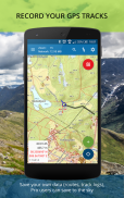
- रजिस्टर करें, मापें और वर्गीकृत करें -
रुचि के बिंदु, मार्ग, क्षेत्र और रिकॉर्ड ट्रैक पंजीकृत करें। प्रत्येक श्रेणी के लिए रंगों और शैलियों/आइकनों के साथ अपनी स्वयं की श्रेणियां बनाकर डेटा व्यवस्थित करें। यदि वांछित है, तो आपका डेटा GPX फ़ाइलों में/से लिखा और पढ़ा जा सकता है या सभी डिवाइसों और मैप पोर्टल Norgeskart.avinet.no पर सिंक्रनाइज़ किया जा सकता है। आप ऐप में डेटा की सूची से दूसरों के साथ फ़ाइलें भी आसानी से साझा कर सकते हैं।
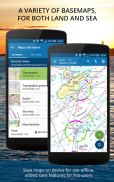
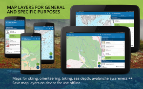
- महान आउटडोर मानचित्र और मानचित्र परतें -
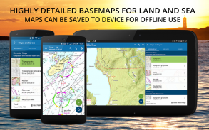
40 से अधिक मानचित्रों और मानचित्र परतों में से चुनें। ऑफ़लाइन उपयोग के लिए यात्रा पर जाने से पहले नॉर्वेजियन मैपिंग अधिकारियों से नॉर्वे के सुंदर मानचित्र डाउनलोड किए जा सकते हैं। कई ऐप्स आपको एक समय में केवल एक परत चालू करने देते हैं, यहां आप अपने परिवेश का संपूर्ण अवलोकन बनाने के लिए जितनी चाहें उतनी परतों को जोड़ सकते हैं। जैसे पिस्ट्स, हिमस्खलन की तीव्रता और कमजोर बर्फ की परतों को चालू करके।
Norgeskart आउटडोर अधिकांश अन्य मानचित्र ऐप्स से भिन्न है क्योंकि यह मर्केटर और UTM दोनों अनुमानित मानचित्रों का समर्थन करता है। इससे यह नॉर्वेजियन मैपिंग अथॉरिटी के स्थलाकृतिक मानचित्रों के उच्च-रिज़ॉल्यूशन यूटीएम संस्करणों को प्रदर्शित करता है। मर्केटर संस्करण की तुलना में यूटीएम सेवाओं में विवरण के 2 अतिरिक्त स्तर हैं।
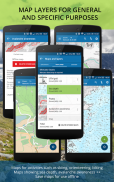
- स्वयं का मानचित्र और मानचित्र परतें -
क्या आपको कोई मानचित्र या मानचित्र परत याद आ रही है? ऐप अब WMS, WMTS, XYZ और TMS सेवाओं से आपके स्वयं के मानचित्र और परतें जोड़ने का समर्थन करता है। नॉर्वे में अतिरिक्त मानचित्रों और परतों के लिए एक बढ़िया स्रोत साइटgenorge.no है। आप अन्य देशों के मानचित्र जोड़ने का भी प्रयास कर सकते हैं, लेकिन ऐप केवल मर्केटर और UTM33 अनुमानों का समर्थन करता है।
- टेलटूर -
Teltur.no से यात्रा सुझावों और विवरणों के साथ अपनी अगली यात्रा की योजना बनाएं। टेलटूर के साथ आप किसी पर्यटन स्थल पर पहुंचने पर पंजीकरण करने के लिए ऐप का उपयोग कर सकते हैं और सबसे अधिक स्थानों पर जाने के लिए दूसरों के साथ प्रतिस्पर्धा कर सकते हैं।
इस ऐप में मुफ़्त और सशुल्क दोनों तरह की सामग्री शामिल है (नीचे संपूर्ण अवलोकन देखें)। सदस्यता के लिए भुगतान करके, आप ऐप के आगे के विकास का समर्थन करते हैं और हमारे द्वारा पेश की जाने वाली सभी रोमांचक चीजों का पूरा लाभ उठाते हैं।
निःशुल्क सामग्री:
------------------
- नॉर्वे, स्वालबार्ड और जान मायेन के लिए मर्केटर स्थलाकृतिक और समुद्री मानचित्र
- गर्मी और सर्दी में खुले हवाई मार्ग
- रन आउट के साथ स्थिरता
- कर्सर स्थिति के लिए स्थान का नाम और ऊंचाई/गहराई देखें
- स्थान के नाम, पते या निर्देशांक खोजें
- GPX फ़ाइलों का आयात और निर्यात
- आरेख और विवरण के साथ ट्रैक रिकॉर्डिंग
- मार्ग और POI बनाएँ
- दिशा सूचक यंत्र
- संपत्ति सीमाएँ
प्रो सदस्यता:
------------------
- ऑफ़लाइन उपयोग के लिए नॉर्वेजियन मानचित्र डाउनलोड करें
- स्थलाकृतिक मानचित्रों के अतिरिक्त विस्तृत यूटीएम संस्करण
- क्षेत्र बनाएं और मापें
- खुद की श्रेणियां बनाएं
- स्वीडन का टोपो मानचित्र (ऑफ़लाइन, लेकिन डाउनलोड क्षेत्र फ़ंक्शन के बिना)
- POI, ट्रैक और रूट अपलोड करें
- अपने डेटा को सभी डिवाइसों और मानचित्र पोर्टल के साथ सिंक्रनाइज़ करें
- उन्नत गुण परत (कैडस्ट्रे)
- आर्थिक (N5 रेखापुंज) मानचित्र
- ऐतिहासिक मानचित्र
- पगडंडियाँ
- पर्वतीय बाइक मार्ग
- अल्पाइन और क्रॉस-कंट्री के लिए पिस्टेस
- हिमस्खलन जागरूकता और घटनाएं
- कमजोर बर्फ
- बर्फ की गहराई और स्कीइंग की स्थिति
- स्नोमोबाइल ट्रैक
- समुद्र की गहराई और झील की गहराई
- एंकरेज
- संरक्षण क्षेत्र
- मिट्टी और रेडॉन
प्रो+ सदस्यता (199 नॉक प्रति वर्ष):
------------------
- सभी प्रो में
- नॉर्वे और स्वालबार्ड के लिए ऑर्थोफोटो मानचित्र
- अपने स्वयं के मानचित्र और परतें जोड़ें
- आधारशिला मानचित्र परत
- ऑनलाइन केएमएल फाइलों से अंकों का आवधिक अद्यतन। टेलीस्पोर के साथ परीक्षण किया गया।
Norgeskart Outdoors - एपीके जानकारी
एपीके संस्करण: 3.28पैकेज: no.avinet.norgeskartLatest Version of Norgeskart Outdoors
अन्य संस्करण


 3.98
3.98Apps in the same category

You may also like...


